Mullayanagiri Trek —
Karnataka's Highest Peak
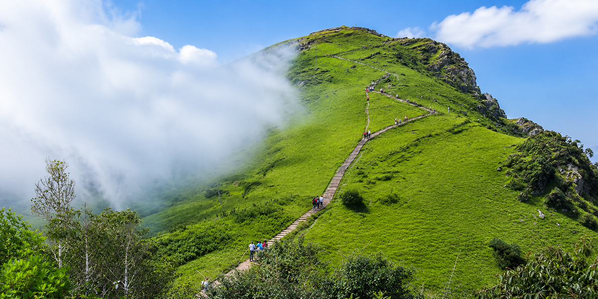
Mullayanagiri is the highest peak in Karnataka, rising to 1,930 metres in the Baba Budangiri range of the Western Ghats, in Chikmagalur district. On a clear day, the summit gives you an uninterrupted view of the surrounding Western Ghats — rolling shola grasslands, coffee estates, and, in the monsoon, clouds rolling in below eye level.
The peak takes its name from Mulappa Swamy, a saint believed to have meditated in the caves near the summit. A small shrine at the top, along with the nearby caves, still draws both trekkers and pilgrims.
Most articles blur Mullayanagiri's trekking options into one — but there are genuinely different experiences, and knowing which one you're signing up for matters. Sarpadari represents the authentic trekking challenge, while the steps route offers a short, paved walk for sightseers.
At a Glance: Key Trail Metrics
Location
Baba Budangiri range, Chikmagalur, Karnataka
Peak Altitude
1,930 m (6,330 ft)
Duration
2.5–3.5 Hours (Sarpadari)
Ideal Season
September to February
| Extended Trail Specifications | |
|---|---|
| Distance from Bangalore | ~265–280 km (approx. 6–6.5 hours by road) |
| Distance from Chikmagalur town | ~20–22 km |
| Permits & Gate Fees | None for Mullayanagiri; required only if continuing on to Baba Budangiri |
| Extended Route Option | Ridge trek extending to Baba Budangiri (~10 km) |
| Nearest Points | Chikmagalur Town (~20 km) | Chikmagalur Railway | Mangalore Airport (~140 km) |
Two Ways to Experience Mullayanagiri
Before you pack, understand the two distinct routes used to reach the highest point in Karnataka:
1. The Paved Steps Route
You drive up the ghat road directly to a parking area close to the summit, then climb a set of stone steps (approximately 200 to 450 steps depending on where you start counting) to reach the peak and the shrine. This takes about 30–45 minutes round trip and needs no prior fitness preparation.
2. The Sarpadari Trek
This is the real Mullayanagiri trek — starting on foot from Sarpadari ("sarpa" = snake, "dari" = way in Kannada), a marked arch off the main ghat road roughly 15 km from Chikmagalur town. From here, it's a 3–4 km climb through forest and grassland to the summit, taking 2.5–3.5 hours.
Recommendation: If someone tells you they've "done the Mullayanagiri trek," ask which one — it changes the difficulty level completely.
The Sarpadari Trek Route Section by Section
This is the timeline and checkpoint breakdown for the authentic 3–4 km Sarpadari foot trail:
The Serpent's Incline
The trail starts steep from the Sarpadari arch — with an incline reaching 60 degrees or more during the initial stretch — as you climb through dense bushes and low forest. This serves as the primary physical barrier of the trail, but relents after the first hour as the forest gives way to open shola grasslands.
Grasslands & Nandi Shrine
About two hours in, you will pass a stone Nandi (bull) statue resting under a solitary tree, surrounded by endemic Western Ghats shrubs. Directly past this landmark, you reach a set of natural caves colored by mineral deposits and inhabited by local bat colonies.
Mullappa Swamy Summit
A final brief, ascending stretch brings you to the breezy summit. The highest point in Karnataka is marked by a second Nandi statue, a Shiva temple, and the Mullappa Swamy shrine. On a clear day, you are rewarded with an uninterrupted 360-degree panoramic view of the Western Ghats.
Extending the Trek to Baba Budangiri
Experienced trekkers often combine Mullayanagiri with a further ridge walk to Baba Budangiri, a mountain range sacred to both Hindu and Muslim pilgrims. This adds roughly 10 km of trekking over exposed ridges and high-altitude grassland.
Permit and Safety Warning for Extensions
- Mandatory Gundi checkpost permission: The extension path passes through Gundi forest checkpost. You are required by law to secure Forest Department permission to traverse this line.
- No permits required for Mullayanagiri alone: If you only trek from Sarpadari to the Mullayanagiri peak, you do not need any permits.
- Exposed BSNL Tower ridge drop-offs: The ridge section near the BSNL tower on this extension becomes exceptionally narrow, with sheer drop-offs on either side. Do not attempt this stretch without an experienced local guide.
Best Time to Visit
September to February
Temperatures range between 14°C and 32°C. This window offers the highest visibility and is ideal for capturing standard peak-top panorama photographs.
Monsoon (June – August)
The hills turn lush green, but fog reduces visibility near the summit to zero. Sarpadari's initial steep incline becomes muddy and slippery. A professional guide is highly recommended.
Weekends & Holidays
Because tourists drive up near the summit, the narrow ghat roads experience severe vehicle blockages. Expect delays on roads if traveling during peak hours.
How to Reach Mullayanagiri
By Road: Bangalore → Hassan → Belur → Chikmagalur → Sarpadari (~265–280 km, about 6–6.5 hours). From Chikmagalur town, head towards Baba Budangiri; about 8 km out, at Kaimara, take the left fork towards Mullayanagiri. The Sarpadari arch is on the left side of the road, roughly half a kilometer past the fork.
By Public Bus: KSRTC runs frequent bus services connecting Bangalore to Chikmagalur town. Local buses, shared jeeps, and autos run the remaining 15–20 km from town to the trailhead.
By Train: The closest railway terminus is located in Chikmagalur town.
By Air: Mangalore International Airport is the nearest airport, located approximately 140–150 km from Chikmagalur.
Difficulty Levels: Who Should Attempt This?
Depending on which route you choose, the difficulty level shifts significantly:
Paved Steps Route
Short steps up from the parking area. Accessible for children, elders, and casual weekend tourists with zero prep.
Sarpadari Trail
Approving for beginners with basic cardiovascular stamina. Hardest part is the first 60-degree steep, muddy climb.
Baba Budangiri Ridge
10 km exposed ridge crossing. Recommended for seasoned hikers. Guide and forest checkpost clearance required.
Mullayanagiri Trek Packages by TheBTC
We organize regular weekend trekking batches from Bangalore. Let us handle the transport and guide logistics while you experience the Western Ghats:
Weekend Group Package
- Duration: 2 Days / 1 Night (weekend batch)
- Transport: Round-trip private bus from Bangalore
- Stay: Cozy shared homestay accommodation near Chikmagalur
- Meals: Traditional meals (base breakfast, trail lunches, homestay dinner)
- Guides & Permits: Certified trek guides & Baba Budangiri forest permits
*Excludes personal gear. Batch size capped to protect nature trails.
What to Pack for the Trek
Mullayanagiri is a short, half-day trek, but because there are no food stalls or water sources along Sarpadari trail, you must remain self-sufficient:
Essential Gear
- 1.5–2 litres of water (No water source on trail)
- Trekking shoes with strong, deep grip
- Raincoat or waterproof travel poncho
- A light cap, UV sunglasses, sunscreen
- Personal medication & basic first-aid kit
- Energy bars, trail mix, dates (Packed in reusable box)
- Fully charged phone/camera + power bank
Not Allowed on Trail
- Single-use plastic bottles
- Packaged chip bags with disposable plastic
- Alcohol and associated substances
- Littering of any food wrappers
Nearby Highlights
- Baba Budangiri Range (Trek extension)
- Kemmanagundi Hill Station
- Hebbe Falls inside forest reserves
- Manikyadhara Falls
- Kalhatti Falls and associated shrine
The Legend Behind the Name
Mullayanagiri is named after Mulappa Swamy, a saint said to have spent years in meditation in the caves near the summit. A small shrine dedicated to him — along with a Shiva temple — still stands at the peak today, and is why the caves and summit remain a spot of quiet pilgrimage as much as a trekking destination.
| Emergency & Safety Contacts | |
|---|---|
| Hospitals | Kalasa Government Hospital | Sri Manjunatha Memorial & Kaveri Hospital (082632 74628) |
| Police Help | Kalasa Police Station (09480805159) |
| Forest Office | Kudremukh Range Forest Officer (08263255998) — call for emergency permissions |
| National Helpline | Dial 112 |