Gangadikal Trek —
Kudremukh's Hidden Ridge Walk
Gangadikal is one of the lesser-known peaks inside Kudremukh National Park — overshadowed by its famous neighbour Kudremukh, but arguably offering a more dramatic walk. The trail runs along a narrow ridge with a steep valley dropping away on both sides, opening up to views of the Kudremukh range that you simply don't get from the more popular peaks nearby.
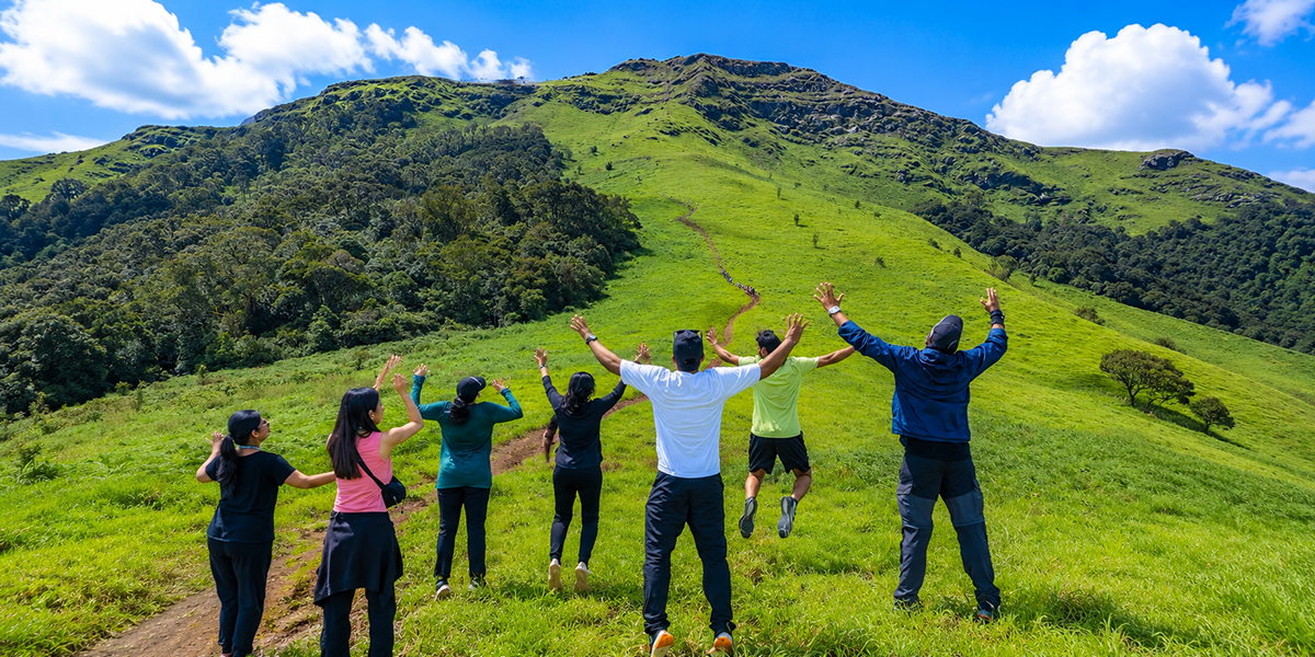
From the summit, you can see the backwaters of the Lakhya Dam resting on the shola grasslands below, and on a clear day, the abandoned mining town of Kudremukh next to it. Because it sees far fewer trekkers than Kudremukh or Netravati, it has a genuinely quieter, more untouched feel.
Set your expectations honestly: several trekkers who've done this route report the summit fully wrapped in mist and cloud with zero visibility on the day. This is genuinely possible, especially just after monsoon — it doesn't mean anything went wrong, it's just how a Western Ghats peak trek can go.
At a Glance: Key Trail Metrics
Location
Kudremukh National Park, Chikmagalur district
Peak Altitude
1,465 m (4,806 ft)
Duration
~4 Hours Total
Ideal Season
Late September to January
| Extended Trail Specifications | |
|---|---|
| Distance from Bangalore | ~330–350 km (approx. 7–8 hours by road) |
| Trek Distance | ~4 km one way / ~8 km round trip (corroborated distance) |
| Permits & Gate Fees | Mandatory online forest permit required via Aranya Vihaara |
| Guide Requirement | Compulsory (assigned by the Forest Department at the office) |
| Nearest Points | Kudremukh Town | Kalasa (~20 km from base) | Mangalore Airport (~140 km) |
*Note on figures: some commercial trek listings quote the round-trip distance as anywhere from 8 to 14 km. We've cross-checked multiple independent trekker accounts and gone with the consistently corroborated ~4 km one way — the higher figures likely include extra walking at the base or combine it with a visit to the hanging bridge.
The Route Section by Section
The trek starts at a forest checkpost off the main road, where a small parking area marks the trailhead — this is a different location from the permit office in Kudremukh town:
The Jeep Track Section
The first stretch of the trek runs along a well-marked forest jeep trail. It offers an easy, pleasant walking warm-up under dense canopy tree cover before climbing up to the ridge lines.
Forest to Grassland
A gradual climb takes you out of the forest cover into open shola grasslands. Here, you get your first clear look at the majestic Gangadikal ridge ahead — keep an eye out for a small metal tower structure at its centre which marks your target destination.
The Climb & Viewpoints
After a brief forest patch with a natural cave-like canopy of branches, the trail gets steep for the final push to the first viewpoint (a flat open clearing). From there, a zigzag ascent through grassland and loose, iron-rich gravel takes you up to the second viewpoint, onto the narrow ridge, and finally the peak.
Descent Note: You return the same way. The stretch from the peak back down to the second viewpoint is the trickiest part of the whole trek — loose gravel and boulders can shift underfoot, so lean into the hill and place your feet deliberately. Past the second viewpoint, the descent gets much easier. Most groups are expected to start descending from the peak by 1–2 PM to ensure a safe return to the checkpost before dark.
Permits — Read This Before You Plan Anything Else
Because Gangadikal lies inside a highly protected wildlife zone, the Forest Department maintains a strict system that catches many walk-in trekkers off guard:
Permits & Office Check-in Guidelines
- Book online in advance: Slots must be reserved on the official Aranya Vihaara portal (aranyavihaara.karnataka.gov.in) under Chikmagalur district. Walk-in bookings are not accepted.
- Bring your Reference ID: Keep the email reference number handy. Report to the Kudremukh Forest Office (located inside Kudremukh town) to show your reference, fill out forms, and settle the final guide fee.
- Arrive before 10 AM: Guides are assigned at the office on a first-come, first-served basis and are generally not available after 10 AM. Arriving late means you cannot trek.
- Carry physical ID: Aadhar cards are highly preferred. Soft copies are occasionally rejected, so keep a hard print handy.
- Trailhead distance warning: The Kudremukh Forest Office (where you complete formalities) and the actual Gangadikal trailhead are two completely different locations, roughly 8 km apart. Budget driving time between the two.
- No Camping Allowed: Camping inside Kudremukh National Park is illegal. Violators face heavy fines.
Best Time to Visit
Planning around the seasons is critical to avoid trail closures or dangerous hiking conditions:
Late September to January
Post-monsoon vegetation turns the park incredibly green, winds drop, and cloud clarity near the summit is at its peak.
February to May
Landscape dries to a yellow-brown tint. During peak summer (April-May), the Forest Department frequently suspends all permits due to wildfire risks in the shola range.
June to September (Monsoon)
High rainfall turns Sarpadari and Gangadikal paths muddy and extremely slippery. Permits may be suspended without warning during heavy downpours.
How to Reach Gangadikal from Bangalore
By Road (Highly Recommended): Bangalore → Hassan → Chikmagalur → Kalasa (~330–350 km, approx. 7–8 hours). From Kalasa town, continue towards Kudremukh town (~20 km) to complete forest office check-in formalities, then head to the trailhead located off the Kalasa–Karkala road.
By Public Transport: This route is genuinely difficult by public transport. KSRTC buses run from Bangalore to Kalasa, but onward connections from Kalasa to Kudremukh and then to the trailhead are infrequent, and you may end up waiting for connecting buses at multiple points — realistically risking missing the 10 AM guide cutoff. If you're not driving yourself, a private vehicle or organised transport for the last stretch is strongly recommended.
By Rail: Nearest railway station is Mangalore Junction (~140 km) or Kadur (~110 km, on the Chikmagalur line).
By Air: Nearest airport is Mangalore International Airport, roughly 140–150 km away.
Difficulty Level — Who Should Attempt This?
Gangadikal is graded easy-to-moderate overall — the jeep-track and grassland sections are gentle, and it's a realistic first "real" Western Ghats trek for a beginner:
Jeep & Grassland Stretch
The first 4 km offer wide trails, gradual inclines, and stable footing under tree canopy. Suitable for families and first-time hikers.
First Viewpoint Climb
The short section approaching the first viewpoint gets steep quite quickly, requiring good breathing rhythm and leg strength.
Peak Descent Section
The narrow path heading down from the peak is covered in loose gravel and shifting iron-rich stones. Tread carefully with bent knees to prevent slips.
Gangadikal Trek Packages by TheBTC
Skip the stress of booking permits and arranging Kalasa transfers. Join our organized weekend batches from Bangalore:
Doing It Yourself (DIY)
- Forest Permit: ~₹500–580 (Aranya Vihaara)
- Mandatory Guide: ~₹100 (Shared across group)
- Local Shuttles: ~₹225–300 (Kalasa auto & jeep base transfers)
- Stay & Food: ~₹1,000–1,500 (Local homestay near Samse)
*Excludes transport from Bangalore. Best for groups of 4+ with private vehicles.
Weekend Group Package
- Duration: 2 Days / 1 Night (weekend batch)
- Transport: Round-trip private bus from Bangalore
- Formalities: All forest permit handling & guide fees included
- Stay & Food: Shared homestay near Kalasa, base meals included
- Sightseeing: Side stops like Kudremukh hanging bridge included
*Recommended for solo hikers and those wishing to skip permit reservation logistics.
What to Pack for the Trek
Kudremukh National Park maintains strict checkposts. Pack responsibly and avoid bringing single-use plastics onto the trail:
Essential Gear
- 2 litres of water (No water source on trail)
- Trekking shoes with strong, deep grip
- Raincoat or waterproof travel poncho
- A light cap, UV sunglasses, sunscreen
- Personal ID (Aadhar preferred) for forest check
- Steel dabba / lunch box for packed lunches
- Solid cash (UPI fails past Kalasa)
Not Allowed on Trail
- Single-use plastic bottles
- Packaged chip bags with disposable wrap
- Open campfires or smoking on trail
- Littering of any food wrappers
Nearby Highlights
- Kurinjal Peak (Separate day trek)
- Kudremukh Peak (Most iconic trail)
- Kudremukh Hanging Bridge
- Hanuman Gundi Falls inside the park
- Horanadu Temple on Bhadra River
Practical Reality-Check (Not on Most Trek Pages)
No Storage Facilities
No cloakrooms or lockers exist at the forest checkpost trailhead. Whatever gear you bring from Kalasa must be carried up and down on your back.
Patchy Mobile Network
Mobile coverage is completely absent on the lower jeep trail, with only a rare bar of signal near the summit peak. Inform families of your itinerary beforehand.
Kalasa is the Cash Hub
UPI and card readers are completely unavailable once you cross Kaimara. Ensure you withdraw sufficient hard cash in Kalasa town before starting.
Accommodations Note: The closest government-run stay option in the area is Bhagavathi Nature Camp near the park, though a private vehicle is required to reach it. Otherwise, Kalasa and Samse are the practical base towns for booking an overnight stay.
Emergency Contacts & Wildlife
Gangadikal Peak is a rich habitat for Malabar giant squirrels, common langurs, and a wide array of high-altitude frogs. Please respect their home. For any safety issues, keep these contacts saved on your phone:
| Emergency & Safety Contacts | |
|---|---|
| Hospitals | Kalasa Govt Hospital | Sri Manjunatha Memorial Hospital (082632 74628) — ~20 km away |
| Police Help | Kalasa Police Station (09480805159) |
| Forest Office | Kudremukh Range Forest Officer (08263255998) — call for emergency permissions |
| National Helpline | Dial 112 |